During the study of soil composition for the presence of potentially toxic metals, a group of scientists from the Laboratory of Neutron Physics at JINR obtained an interesting result. They discovered a correlation between the pollution map and the soil map based on satellite images. According to the researchers, under certain conditions, this correlation can be used to identify areas of massive soil contamination in places where it is impossible to collect samples.
Nowadays, soil pollution with potentially toxic metals is a serious problem due to the growing industrialisation and urbanisation worldwide. It affects both rural and urban areas. Most toxic metals are biologically active and hardly removed from the ecosystem. As a result, it can lead to a number of adverse consequences for the environment and human health.
At the same time, there are only few studies on the ecology of small cities. JINR scientists chose the town of Kolchugino in the Vladimir Region. There are many non-ferrous metallurgy plants in the town that significantly affect its ecology.
The researchers determined the levels of four metals of the 1st and 2nd toxicity classes in the selected soil samples: Zn, Pb, Cu, and Cd. They analysed the samples using the atomic absorption spectrometer (AAS). The scientists calculated the potential ecological risk, the pollution load index, and total pollution index for the assessment of anthropogenic soil pollution. In order to identify the sources of soil contamination, they carried out multivariate statistical analysis.
Researchers determined the mass fractions of four heavy metals and mapped them. They calculated pollution levels and created topological maps of soil contamination areas using a set of ArcGIS geographic information software products. It made it possible to identify areas of serious pollution with heavy metals.
During the next stage of the research, scientists identified areas with differences in land use and land cover (LULC) in the studied territory by using remote sensing methods. The scientists used images with a spatial resolution of 30 meters from the Operational Land Imager (OLI), which acquired the data on 31 July 2021. The maximum likelihood estimation method was employed to classify satellite images in order to obtain a LULC map.
Based on the results, six land use and land cover types were identified, namely: urban, water, green, forest, swamp, and industrial areas. LULC analysis showed that the urban type is dominant among the six types. The locations of peak pollution spots were identified as industrial areas, which is quite comparable with the obtained results of pollution indices.
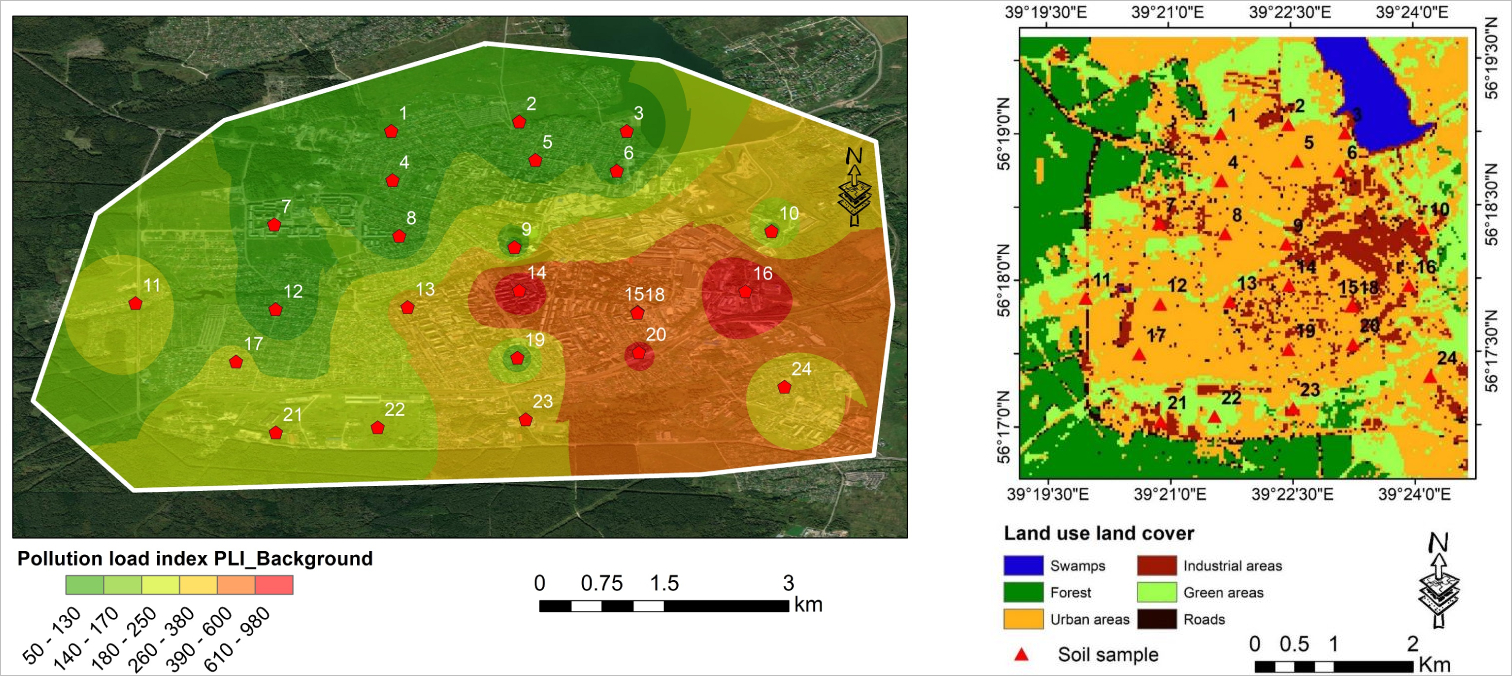 On the left: soil contamination topological map with calculated pollution indices; on the right: LULC map based on satellite images
As the scientists emphasised in their research, the data obtained can provide scientific evidence of heavy metal pollution in an industrial city. It can also help identify areas where emission control measures need to be taken, e.g. increasing recycling or implementing stricter waste management laws.
“When we found similarities between the satellite images and the map created during our study, we suggested that we could use this method to assess soil pollution in areas where sampling is not possible. That is, we could simulate the situation based on the LULC map,” an FLNP senior researcher Wael Badawy, one of the authors of the study said. “And this approach seems to be very promising from the point of view of environmental research”.
However, as the scientist noted, currently this method does not provide an answer to the question of what exactly the soil is contaminated with, which element has an exceeded concentration. Satellite images provide only an overall picture, so these photographs cannot be used to differentiate pollution areas yet. “We will definitely continue our work”, Wael Badawy concluded. “In different places and at different times of the year, we will observe the dynamics and include machine learning, we will create models for finding patterns”.
Article link
- Inna Z. Kamanina, Wael M. Badawy, Svetlana P. Kaplina, Oleg A. Makarov, Sergey V. Mamikhin. Assessment of Soil Potentially Toxic Metal Pollution in Kolchugino Town, Russia: Characteristics and Pollution. Land 2023, 12(2), 439; https://doi.org/10.3390/land12020439